Evaluation of Best Satellite-Receiver Geometry for Improved IRNSS/GPS Position Accuracy
Article Sidebar
Main Article Content
Abstract
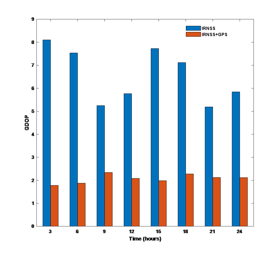
A GPS-IRNSS combined navigation system is emerging in India. It is possible to increase the accuracy of the receiver or user's position at any time and under any weather conditions with a combined system. It is possible to use these navigation systems for finding the precise location of receivers in civil aviation, precision applications such as surveying, disaster management, and other applications. Usually, satellite navigation systems are based on a geometric relationship between satellite and receiver, with errors caused by atmospheric conditions, multipath, and other factors affecting accuracy. Geometry of satellite receivers is measured by the Dilution of Precision (DOP), a unit less quantity. This paper investigates the possibility possible to obtain better accuracy by combining GPS and IRNSS constellations. This improved accuracy is typically useful for precision applications such as surveying and disaster management.
Article Details
References
S. Dan, A. Santra, S. Mahato, and A. Bose, “NavIC performance over the service region: availability and solution quality,” Sadhana - Acad. Proc. Eng. Sci., vol. 45, no. 1, pp. 1–7, 2020 , doi: 10.1007/s12046-020-01375-5.
C. Rajasekhar, V. B. S. Srilatha Indira Dutt, and G. Sasibhushana Rao, "Investigation of Best Satellite–Receiver Geometry to Improve Positioning Accuracy Using GPS and IRNSS Combined Constellation over Hyderabad Region," Wireless Personal Communication, vol. 88, no. 2, pp. 385–393, 2016, doi: 10.1007/s11277-015-3126-3.
Devireddy K., Narsetty S., Ramavath AK., Perumalla NK. (2021), "Validation of the IRI?2016 model with Indian NavIC data for future navigation applications," ET Radar Sonar Navig. 15:37–50. https://doi.org/10.1049/rsn2.12013.
Devireddy, K., Abedin, N. U., Kuna, D., and P. N. Kumar, "Analysis of Various Parameters of L5 and S1 NavIC Signals over Low Latitude Region," Procedia Comput. Sci., vol. 171, no. 2019, pp. 2704–2712, 2020, doi: 10.1016/j.procs.2020.04.293.
Devadas Kuna, Naveen Kumar, P., Anil Kumar, R. "Positioning Parameters for Standalone and Hybrid Modes of the Indian NavIC Systems: Preliminary Analysis," International Conference on Emerging Trends in Engineering (ICETE), 22-23 March 2019, University College of Engineering, Osmania University, Hyderabad.
T. Sridher, A. D. Sarma, and P. Naveen Kumar, "Performance Evaluation of Onboard Wi-Fi Module Antennas in Terms of Orientation and Position for IoT Applications," International Journal of Engineering, vol. 35, no. 10, pp. 1918–1928, 2022, doi: 10.5829/ije.2022.35.10a.11.
Kakulapati, V., Singh Gill, G. ., R., C. ., Srivastava, S. ., Sharma, M. ., & Kumar , V. . (2023). Importance of Artificial Intelligence in Neural Network: Speech Signal Segmentation Using K-Means Clustering with Kernelized Deep Belief Networks. International Journal of Intelligent Systems and Applications in Engineering, 11(3s), 144–149. Retrieved from https://ijisae.org/index.php/IJISAE/article/view/2552
Kaplan, E. D., Christopher, J. H., Understanding GPS: Principles and applications. (2nd ed.), (2006), Boston: Artech House Press.
Mosavi, M. R., “Applying genetic algorithm to fast and precise selection of GPS satellites,” Asian Journal of Applied Sciences, 4, 2011, 229–237.
Wu, C.-H., et al., “Study on GPS GDOP approximation using support-vector machines,” IEEE Transactions Instrumentation and Measurement, 2011, 60(1), 137–145.
Sharp, I., “GDOP analysis for positioning system design,” IEEE Transactions on Vehicular Technology, 58(7), 230–245, 2009.
Lohani, B., & Kumar, R., “GPS-GDOP prediction in urban environment using LiDAR data”, Journal of Applied Geodesy, 2, 213–222, .2008
Srilatha Indira Dutt, V. B. S., et al., (2009), “Investigation of GDOP for precise user position computation with all satellites in view and optimum four satellite configuration,” Journal Of Indian Geophysical Union, 13(3), 139–148.
Indian Space Research Organization. Indian Regional Navigation Satellite System programme, http:// isro.gov.in/irnss-programme.
Scripps Orbit Permanent Array Center (SOPAC), IGS Data Achieve, http://sopac.ucsd.edu/ dataBrowser.html.
Hegarty, C. J., Chatre, E. (2008), “Evolution of the Global Navigation Satellite System (GNSS),” In Proceedings of the IEEE, (Vol. 96, PP. 1902–1917), 2006090. doi:10.1109/JPROC.2008.
Neelakantan, N. (2010), “Overview of Indian Satellite Navigation Programme,” In 5th meeting of the International Committee on Global Navigation Satellite Systems (ICG), jointly organized by Italy and the European Commission, Turin.
Singh, A., Saraswati, S. K. (2006), “India Heads for a Regional Navigation Satellite System Coordinates,” a magazine on positioning and navigation.
Li, B., Zhang, S., Dempster, A. G., & Rizos, C. (2011), “Impact of RNSSs on positioning in the Asiav Oceania region,” Journal of Global Positioning Systems, 10(2), 114–124.
Rao, G. S. (2010), Global navigation satellite systems. New Delhi: McGrawHill Edition.
Muñoz, S., Hernandez, M., González, M., Thomas, P., & Anderson, C. Enhancing Engineering Education with Intelligent Tutoring Systems using Machine Learning. Kuwait Journal of Machine Learning, 1(2). Retrieved from http://kuwaitjournals.com/index.php/kjml/article/view/116
Parkinson, W. B., Spilker, J. J. (1996), Global positioning system: theory and applications—Vol. I and II, Institute of Aeronautics and Astronautics Inc, Washington.
Juan Lopez, Machine Learning-based Recommender Systems for E-commerce , Machine Learning Applications Conference Proceedings, Vol 2 2022.
Langley, R. B. (1999). Dilution of precision, GPS World, 10(5), 52–59.
Senanayake, I. P. (2013), “Anticipated prospects and civilian applications of Indian satellite navigation service in Sri Lanka,” The Egyptian Journal of Remote Sensing and Space Science, 16(1), 1–10.