Implementation of Super Resolution Techniques in Geospatial Satellite Imagery
Article Sidebar
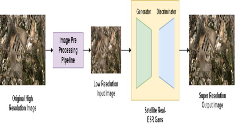
Main Article Content
Abstract
The potential for more precise land cover classifications and pattern analysis is provided by technological advancements and the growing accessibility of high-resolution satellite images, which might significantly improve the detection and quantification of land cover change for conservation. A group of methods known as "super-resolution imaging" use generative modelling to increase the resolution of an imaging system. Super-Resolution Imaging, which falls under the category of sophisticated computer vision and image processing, has a variety of practical uses, including astronomical imaging, surveillance and security, medical imaging, and satellite imaging. As computer vision is where deep learning algorithms for super-resolution first appeared, they were mostly created on RGB images in 8-bit colour depth, where the sensor and camera are separated by a few meters. But no evaluation of these methods has been done.
Article Details
References
L. Zhou, G. Chen, M. Feng and A. Knoll, "Improving Low-Resolution Image Classification by Super-Resolution with Enhancing High-Frequency Content," 2020 25th International Conference on Pattern Recognition (ICPR), Milan, Italy, 2021, pp. 1972-1978, doi: 10.1109/ICPR48806.2021.9412876.
J. Sun, Z. Xu and H.-Y. Shum, "Image super-resolution using gradient profile prior", IEEE international conference on computer vision (CVPR), 2008.
E. Agustsson and R. Timofte, "Ntire 2017 challenge on single image super-resolution: Dataset and study", The IEEE Conference on Computer Vision and Pattern Recognition (CVPR) Workshops, 2017.
Shimizu, M.; Yoshimura, S.; Tanaka, M.; Okutomi, M., "Super-resolution from image sequence under influence of hot-air optical turbulence," Computer Vision and Pattern
Recognition, 2008, CVPR 2008. IEEE Conference on , vol., no., pp.1,8, 23-28 June2008 doi: 10.1109/CVPR.2008.4587525
Zilin Wang, Zhaoxiang Zhang, Limin Dong, Guodong Xu, “ Jitter Detection and Image Restoration Based on Generative Adversarial Networks in Satellite Images”, 2021 Jul 9, 21(14):4693, doi: 10.3390/s21144693.
Prof. Naveen Jain. (2013). FPGA Implementation of Hardware Architecture for H264/AV Codec Standards. International Journal of New Practices in Management and Engineering, 2(01), 01 - 07. Retrieved from http://ijnpme.org/index.php/IJNPME/article/view/11
Koushlendra Kumar Singh, Manish Kumar Bajpai, and Rajesh Kumar Pandey, “A Novel Approach for Enhancement of Geometric and Contrast Resolution Properties of Low Contrast Images” IEEE/CAA Journal of Automatic Sinica, Vol. 5, No. 2, March 2018
Ying Zhang, Yifang Yin2 , Roger Zimmermann, Guanfeng Wang , Jagannadan Varadarajan, See-Kiong Ng, “An Enhanced GAN Model for Automatic Satellite-to-Map Image Conversion” 18 September 2020, DOI: 10.1109/ACCESS.2020.3025008.
Kun Zheng, Mengfei Wei, Guangmin Sun, Bilal Anas, Yu Li, “Using Vehicle Synthesis Generative Adversarial Networks to Improve Vehicle Detection in Remote Sensing Images, ISPRS Int. J. Geo-Inf. 2019, 8, 390; doi:10.3390/ijgi8090390
Swetava Ganguli, Pedro Garzon, Noa Glaser, “GeoGAN: A Conditional GAN with Reconstruction and Style Loss to Generate Standard Layer of Maps from Satellite Images”, CoRR abs/1902.05611 (2019)
Marc Bosch, Rodrigo Rene Rai Munoz Abujder, and Christopher Gifford "Towards image and video super-resolution for improved analytics from overhead imagery", Proc. SPIE 10992, Geospatial Informatics IX, 1099203 (13 May 2019); https://doi.org/10.1117/12.2518179
Demiray, B.Z., Sit, M. & Demir, I. D-SRGAN: DEM Super-Resolution with Generative Adversarial Networks. SN COMPUT. SCI. 2, 48 (2021). https://doi.org/10.1007/s42979-020-00442-2
Tao Zhang , Hong Tang , Yi Ding , Penglong Li , Chao Ji , Penglei Xu, “ FSRSS-Net: High-Resolution Mapping of Buildings from Middle-Resolution Satellite Images Using a Super-Resolution Semantic Segmentation Network”, Remote Sensing ( IF 5.349 ) PubDate: 2021-06-11 , DOI:10.3390/rs13122290
Xintao Wang1 Liangbin Xie?2,3 Chao Dong2,4 Ying Shan, “Real-ESRGAN: Training Real-World Blind Super-Resolution with Pure Synthetic Data”, 2021 IEEE/CVF International Conference on Computer Vision Workshop (ICCVW)
Zihao Wei, Yidong Huang, Yuang Chen, Chenhao Zheng, Jinnan Gao, “A-ESRGAN: Training Real-World Blind Super-Resolution with Attention U-Net Discriminators” , https://doi.org/10.48550/arXiv.2112.10046
Wang, X. et al. (2019). ESRGAN: Enhanced Super-Resolution Generative Adversarial Networks. In: Leal-Taixé, L., Roth, S. (eds) Computer Vision – ECCV 2018 Workshops. ECCV 2018. Lecture Notes in Computer Science(), vol 11133. Springer, Cham. https://doi.org/10.1007/978-3-030-11021-5_5